Wearable Livestock Trackers Are Changing How New Zealand Farmers Manage Their Herds

A New Era of Smart Farming in New Zealand

New Zealand’s agricultural industry has always depended on practical knowledge, reliable equipment, and the ability to manage livestock across large and often challenging landscapes. From the rolling dairy pastures of Waikato to the steep sheep and beef stations of Otago and Canterbury, farmers face a constant challenge: keeping track of animals while making the best possible use of available land.

Today, technology is changing how that challenge is approached. Wearable livestock trackers, GPS-enabled collars, wireless sensors, and cloud-connected farm management platforms are becoming increasingly important tools in modern agriculture. Instead of relying entirely on physical inspections and traditional fencing, farmers can increasingly monitor animal locations, observe behaviour, and make management decisions using information collected throughout the day.

This development is particularly relevant to New Zealand, where farming operations often cover extensive areas and animals may graze across remote paddocks. Smart livestock tracking is no longer simply an experimental idea. It is developing into a practical part of the country’s agricultural technology landscape.

The growing adoption of these systems also demonstrates how wearable electronics can move beyond consumer products and become essential equipment in industries that contribute significantly to the national economy.

How Wearable Livestock Trackers Actually Work

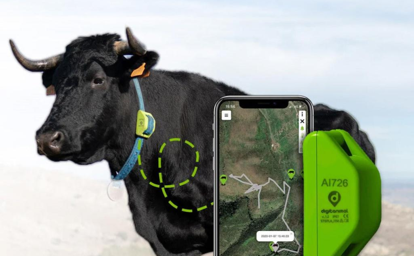
Modern livestock tracking systems combine several technologies into a relatively compact wearable device. A collar fitted around an animal’s neck can contain positioning technology, communication components, motion sensors, and electronic control features.

GPS technology is particularly important because it allows farmers to identify where individual animals or groups of animals are located. Depending on the system, location information can be transmitted to a central platform through cellular networks, farm-based radio infrastructure, or satellite connections.

Farmers can then access this information through a smartphone, tablet, or computer.

For example, a farmer managing several hundred cattle across multiple paddocks can check animal locations without physically travelling around the entire property. If an animal moves beyond an expected grazing area, the system may generate an alert. This can help farmers identify unusual movement patterns and investigate potential problems sooner.

Some advanced platforms also combine location information with behavioural monitoring. Changes in movement, grazing activity, and other patterns can provide useful information about animal health and daily routines.

The real advantage is not simply knowing where livestock are. It is turning continuous information into practical decisions that improve farm management.

New Zealand’s Virtual Fencing Technology Is Gaining Momentum

One of the most interesting developments in New Zealand agriculture is the expansion of virtual fencing.

Traditionally, farmers have needed physical fences to divide grazing areas, control livestock movement, and protect environmentally sensitive land. Building and maintaining these structures can involve substantial costs, particularly on steep or difficult terrain.

Virtual fencing offers another approach.

New Zealand agritech company Halter has developed solar-powered, GPS-enabled smart collars that allow farmers to establish virtual boundaries through a digital platform. When cattle approach a designated boundary, the system uses audio cues and, where necessary, a mild electrical pulse to guide them back.

This technology can make rotational grazing more flexible because farmers can adjust virtual boundaries without physically rebuilding fences.

The development has attracted attention beyond New Zealand. In April 2026, Halter announced a direct-to-satellite virtual fencing solution developed in partnership with One NZ Satellite, powered by Starlink. The technology is designed to help beef farmers manage cattle in remote locations where conventional mobile coverage and farm-based communication infrastructure may be limited.

For a country with extensive high-country farms and geographically challenging agricultural regions, this represents a meaningful technological development.

It also illustrates how wearable electronics, positioning systems, and telecommunications infrastructure are becoming increasingly interconnected.

Why Remote Farms Need Better Tracking Technology

Connectivity remains one of the biggest challenges for agricultural technology.

New Zealand has many farms located outside major urban centres. Some properties include mountainous terrain, isolated valleys, large grazing blocks, and areas where mobile signals are unreliable.

For farmers in these locations, conventional tracking equipment may not provide consistent coverage across the entire property.

A livestock tracker needs more than accurate positioning technology. It also needs a dependable way to communicate information, sufficient operating time, and hardware capable of handling demanding outdoor conditions.

This is where satellite connectivity is becoming increasingly valuable.

Direct-to-satellite communication can extend the reach of connected livestock equipment without requiring extensive local telecommunications infrastructure. It potentially makes advanced tracking systems more accessible to farms that previously faced connectivity limitations.

However, the benefits depend on the service being used, network availability, equipment compatibility, and operating costs.

For farmers considering an investment, these practical details are just as important as the technology itself.

The Importance of Reliable Power in Livestock Tracking Devices

Although GPS positioning and wireless communication receive much of the attention, power management is another essential part of wearable livestock technology.

A tracking collar may need to operate for extended periods while exposed to rain, dust, mud, temperature changes, and continuous animal movement. If its power system is unreliable, even the most advanced software becomes less useful.

Different manufacturers use different power configurations. Some livestock collars incorporate solar-assisted charging, while other tracking devices rely on rechargeable or replaceable battery systems.

The choice depends on the product’s design, communication requirements, sensor activity, and expected operating environment.

For equipment that depends on rechargeable power, the GPS battery is an important component to consider. Its capacity, charging characteristics, durability, and compatibility with the device can all influence how reliably a tracker performs during everyday farm operations.

Farmers should also consider how easily equipment can be inspected and maintained. A device that requires frequent servicing may create additional work, especially when animals are spread across a large property.

As wearable technology becomes more sophisticated, manufacturers will need to balance functionality with efficient energy consumption.

How GPS Tracking Can Improve Animal Health Monitoring

Livestock management is not only about controlling where animals graze. Animal health is equally important.

Traditional livestock inspections remain essential, but farmers cannot observe every animal continuously. When cattle are distributed across large paddocks, identifying subtle behavioural changes can be difficult.

Wearable monitoring technology offers an additional source of information.

Depending on the sensors available, a livestock tracking platform may help identify changes in activity, movement, or grazing behaviour. Unusual patterns could encourage farmers to inspect an animal that might otherwise have gone unnoticed.

For example, reduced movement may indicate an injury, illness, or other condition requiring attention. Changes in daily activity can also provide useful context when assessing animal behaviour.

These systems should not be treated as automatic veterinary diagnostic tools. Data needs to be interpreted alongside direct observation and professional advice.

Nevertheless, the ability to identify potential problems earlier could make farm management more responsive.

For New Zealand livestock businesses, where animal health and productivity are closely connected, this is an important opportunity.

Smarter Grazing and Better Pasture Management

Pasture is one of New Zealand’s most valuable agricultural resources. Efficient grazing management can influence animal growth, production costs, land condition, and the overall performance of a farming business.

Wearable trackers can contribute to more precise grazing decisions by helping farmers understand where animals spend their time and how they move between grazing areas.

When location data is combined with digital paddock maps and pasture information, farmers can make more informed decisions about livestock movement.

Instead of relying entirely on fixed grazing schedules, they can adjust grazing areas according to pasture availability, weather conditions, and the needs of different groups of animals.

This flexibility may be particularly useful during periods of rapid grass growth or changing seasonal conditions.

Gallagher’s eShepherd Moving Fence technology, announced in October 2026, provides another example of how digital livestock management is evolving. The system is designed to move a virtual grazing boundary progressively, allowing farmers to control the pace at which cattle gain access to fresh pasture.

These developments show that livestock wearables are becoming part of a broader digital farming ecosystem rather than remaining isolated tracking devices.

The Growing Role of Agricultural Data

As more farms adopt connected equipment, the amount of information available to farmers is increasing.

Livestock tracking platforms can potentially collect location histories, movement patterns, grazing records, and other operational information. When combined with farm management software, this information can support more detailed analysis.

Farmers may use digital records to compare grazing performance between paddocks, assess animal movement, and identify operational inefficiencies.

The long-term opportunity is to connect different information sources into one practical management environment.

For instance, livestock location data could be considered alongside weather forecasts, pasture measurements, water availability, and production records.

This would allow farmers to make decisions using a more complete picture of farm conditions.

However, collecting more data does not automatically lead to better outcomes. Information needs to be accurate, understandable, and relevant to the decisions farmers actually make.

Technology companies will therefore need to focus on useful software design rather than simply adding more features.

Animal Welfare Must Remain a Priority

Despite the potential benefits, wearable livestock technology also raises important questions about animal welfare.

Virtual fencing systems can use audio signals and electrical stimulation to influence animal movement. This means appropriate training, careful implementation, and responsible monitoring are essential.

Animals need time to become familiar with the system, and farmers must understand how to configure and operate the equipment correctly.

New Zealand’s discussion around virtual fencing reflects these concerns. Farmers, veterinarians, researchers, and animal welfare organisations have considered how the technology should be used and what safeguards may be necessary.

A June 2026 virtual fencing trial on Banks Peninsula, involving Environment Canterbury and Gallagher, examined how GPS collars could help manage cattle on difficult terrain while protecting sensitive wetlands.

The trial demonstrated why local research matters. A system that works well in one farming environment may require adjustments when used in another.

Animal welfare should therefore remain central to product development, farmer education, and the evaluation of new livestock monitoring systems.

What Farmers Should Consider Before Investing

Although smart livestock trackers offer attractive possibilities, adopting them requires careful planning.

First, farmers should assess whether the equipment is suitable for their livestock and property. A system designed for dairy cattle may not necessarily provide the same functionality for extensive sheep and beef operations.

Second, connectivity needs to be evaluated. Farms with reliable mobile coverage may have different requirements from remote properties that need satellite-based communication.

Third, farmers should examine hardware durability. Collars and sensors must withstand regular exposure to moisture, dust, impacts, and outdoor conditions.

Power performance is another important consideration. The GPS battery or integrated power system should match the device’s intended operating requirements, while charging arrangements and replacement options should be clearly understood.

Farmers should also examine software subscriptions, installation expenses, technical support, and data ownership arrangements.

Finally, staff training is essential. Even a sophisticated system may deliver disappointing results if users do not understand how to interpret its information or integrate it into everyday farm routines.

The best investment is not necessarily the device with the largest feature list. It is the system that delivers measurable value under actual farm conditions.

Opportunities for New Zealand’s Agritech Industry

The expansion of wearable livestock tracking creates opportunities for more than farmers.

New Zealand has a strong agricultural knowledge base, and the development of connected livestock technology demonstrates how that expertise can support international technology businesses.

Opportunities exist across hardware engineering, sensor development, positioning systems, telecommunications, cloud software, data analysis, and equipment servicing.

Local suppliers may also contribute through specialised components, rugged electronic enclosures, charging systems, and replacement power solutions.

As connected agricultural equipment becomes more widely used, demand for dependable electronic components will become increasingly important.

In particular, the GPS battery market has opportunities to support tracking devices used in agriculture, livestock management, and other outdoor monitoring applications.

Manufacturers that understand the operating requirements of these devices can help equipment providers improve reliability and extend product life.

New Zealand’s experience may also provide useful lessons for international markets with similar challenges, including Australia, parts of South America, and other regions where livestock are managed across extensive rural landscapes.

The Future of Livestock Management Is Connected

Wearable livestock trackers are changing the relationship between farmers, animals, and agricultural technology.

GPS-enabled collars, virtual fencing, satellite communications, and digital farm management platforms are making it possible to monitor livestock in ways that were difficult or impractical only a few years ago.

For New Zealand, these developments are particularly significant because they address real challenges associated with remote farming, pasture management, labour efficiency, and animal monitoring.

However, successful adoption will depend on more than technological innovation. Reliable hardware, efficient power systems, accessible connectivity, appropriate training, and strong animal welfare practices will all influence the long-term value of these solutions.

The next stage of agricultural development will likely involve closer integration between livestock wearables, farm analytics, environmental monitoring, and automated management systems.

Rather than replacing farmers’ experience, these technologies can provide additional information to support better decisions.

New Zealand has an opportunity to remain an important contributor to this transformation. As smart livestock equipment continues to evolve, the country’s combination of agricultural expertise and technology innovation could help shape how farms operate both locally and internationally.

Google Maps Adds a New Zealand Voice What It Means for Kiwi Drivers

A More Local Navigation Experience for Aotearoa

For many people in New Zealand, Google Maps is an everyday companion. It helps commuters find faster routes through Auckland, guides visitors along the roads of the South Island and makes unfamiliar streets easier to navigate. Yet even a sophisticated navigation app can feel surprisingly disconnected from the country it serves when it struggles to pronounce local place names correctly.

That is beginning to change. Google has introduced a new New Zealand voice for Google Maps, designed to speak English with a Kiwi accent while correctly pronouncing Māori place names. Developed in collaboration with Te Taura Whiri i te Reo Māori, the Māori Language Commission, the update reflects a growing effort to make digital technology more relevant to local communities. The new voice began rolling out in July 2026, with support for Android, iOS, Android Auto and Apple CarPlay. <Cite refs={[“turn550208search0″,”turn550208search3”]}/>

At first glance, a navigation voice might seem like a small software improvement. In practice, it touches several important areas of modern technology, including artificial intelligence, cultural representation, road safety and the way people interact with connected devices.

For New Zealand drivers, the change is a reminder that useful technology is not simply about having more features. It is also about making everyday digital experiences feel more natural, accurate and appropriate for the places where people live.

Why Correct Māori Pronunciation Matters

Aotearoa New Zealand has a distinctive geographical identity, reflected in the names of its cities, towns, mountains, rivers and coastal areas. Many of these names come from te reo Māori and carry historical, cultural and community significance.

When navigation software mispronounces these names, the problem is more than an occasional awkward moment. It can make a familiar location sound unfamiliar and create distance between a digital service and the people who use it.

Google’s new voice aims to address that problem by producing English-language directions with a Kiwi accent while pronouncing Māori place names more accurately. The company worked with language experts and used publicly available information from the New Zealand Geographic Board to support the development process. <Cite refs={[“turn550208search0″,”turn550208search1”]}/>

Consider a driver travelling towards Whangārei or exploring the roads around Taranaki. Hearing these names pronounced appropriately can make spoken directions feel more consistent with local speech. It can also help visitors become more familiar with the names they encounter during their journeys.

The broader message is important. Technology increasingly mediates how people experience the physical world, from finding a business to navigating a remote walking track. When digital products recognise local language and culture, they can become more useful without requiring users to change the way they speak or interact with their surroundings.

How AI Is Making Navigation More Natural

The new Google Maps voice demonstrates how artificial intelligence can improve a familiar product without completely redesigning it.

Rather than introducing an entirely new mapping system, Google has used an AI-powered text-to-speech model to improve the way spoken directions sound. The model was developed using recordings from a Kiwi voice actor, with collaboration from Māori language specialists helping guide pronunciation. <Cite refs={[“turn550208search1″,”turn550208search3”]}/>

This approach highlights an important direction in consumer technology. Some of the most useful AI improvements may appear in the background, quietly making existing tools work better.

Voice technology has already become part of everyday life through smartphones, smart speakers, in-car entertainment systems and digital assistants. However, speaking naturally is not just a matter of choosing a pleasant voice. A good system must also handle names, accents, sentence rhythm and context.

For navigation, these details are particularly important because drivers often rely on short spoken instructions rather than reading the entire map. A clear instruction delivered at the right moment can be easier to follow than a confusing pronunciation that forces someone to glance repeatedly at the screen.

The same principle applies to other voice-enabled products. As AI systems become more capable, consumers will increasingly expect them to recognise local terminology, understand regional accents and deliver information in a way that feels appropriate for their environment.

What the Update Means for Kiwi Drivers

New Zealand’s roads present a wide variety of driving conditions. Urban commuters may deal with congestion, roadworks and complicated intersections, while people travelling between towns may encounter winding highways, changing weather and long stretches with limited mobile coverage.

In these situations, clear navigation is valuable. A driver who understands an instruction immediately can spend more attention watching traffic, checking mirrors and anticipating the next turn.

Google Maps already provides features such as turn-by-turn directions, traffic information and alternative routes. The new voice adds a more locally relevant layer to that established experience. <Cite refs={[“turn550208search4″,”turn550208search6”]}/>

The update will not eliminate every navigation challenge. Drivers must still follow road signs, obey speed limits and use their judgement when digital directions conflict with road conditions. Map information can also be incomplete or delayed, especially when roadworks or temporary closures occur.

Nevertheless, improvements in voice clarity can make a familiar navigation tool easier to use. This is particularly useful when drivers are travelling through unfamiliar areas and cannot afford to spend too much time looking at their phones.

The change may also benefit people who regularly drive between regions. A more recognisable voice can make directions feel consistent throughout a journey, whether someone is heading to work, visiting relatives or setting off on a weekend trip.

Tourism and Road Trips Across New Zealand

Tourism is another area where locally adapted navigation technology can make a difference.

New Zealand attracts visitors interested in dramatic coastlines, geothermal landscapes, mountain scenery, vineyards and outdoor adventures. Many travellers hire cars or campervans to explore places beyond the main cities, making navigation apps an important part of their travel arrangements.

For overseas visitors, Māori place names can initially be difficult to pronounce. Hearing them spoken more accurately offers a small but practical opportunity to become familiar with the language while travelling.

Imagine following directions through the Waikato region, planning a drive towards Rotorua or exploring destinations around the West Coast. A navigation voice that better reflects local pronunciation can help make these journeys feel connected to the places being visited.

This does not mean an app can replace local knowledge. Travellers still need to research access restrictions, check weather conditions and understand the demands of remote roads. In some areas, a downloaded offline map or a dedicated navigation device may be useful when mobile coverage becomes unreliable.

The important point is that technology can support a richer travel experience when it combines practical functionality with an understanding of the local environment.

Smartphones Still Face a Battery Challenge

While navigation software continues to improve, one familiar problem remains: using a smartphone for a long journey can drain its battery quickly.

Google Maps may rely on location services, the display, mobile data and audio output during navigation. Google’s own guidance explains that these activities can increase battery consumption, particularly when the screen remains on throughout a trip. <Cite refs={[“turn550208search4″,”turn550208search6”]}/>

For a short drive across town, this may not be a major concern. For a full day of exploring New Zealand, however, the situation can be different. Travellers may use navigation alongside photography, messaging, music streaming and searching for nearby attractions, placing additional demands on their phones.

There are several practical ways to reduce the problem. Drivers can lower screen brightness, turn off the display when visual guidance is unnecessary and use a suitable vehicle charger. Downloading offline maps before entering an area with weak reception can also reduce reliance on a continuous mobile data connection, although location services and other phone functions may still consume power.

Another option is to use a dedicated GPS navigation device. Depending on the model, these devices can offer a screen designed for vehicle use, specialised routing features and an operating experience that does not depend on a personal smartphone.

Consumers comparing navigation products should consider charging options and expected operating time alongside screen size, map coverage and ease of use. A reliable GPS battery can be particularly relevant to travellers who depend on a dedicated navigation device during long drives or outdoor activities.

Dedicated GPS Devices Still Have a Role

Smartphones have made navigation widely accessible, but dedicated GPS devices have not lost all their value.

Some motorists prefer a separate unit because it can remain mounted in the vehicle without tying up their phone. Others use specialised navigation equipment for outdoor activities, cycling, marine travel or work that requires location information in environments where a smartphone may not be the most convenient option.

The needs of these users can differ considerably. A driver may prioritise clear maps and straightforward charging, while a hiker may place greater importance on weight, durability, route tracking and operation away from mobile networks.

Battery performance is central to these decisions. A device that works well for several hours in ordinary conditions may behave differently when the screen is continuously illuminated, temperatures are low or location tracking is frequent.

Before buying a replacement battery or a new navigation unit, consumers should check the exact device model, the manufacturer’s specifications and the recommended charging requirements. Battery compatibility is not universal, even among products from the same brand.

It is also worth distinguishing between battery capacity and real-world endurance. A larger capacity can be useful, but software efficiency, screen brightness, signal conditions and usage patterns all affect how long a device operates between charges.

For anyone planning extended road trips or outdoor excursions, understanding these factors can help avoid the frustration of losing navigation at an inconvenient moment.

The Importance of Offline Maps and Reliable Positioning

New Zealand’s varied landscape makes connectivity an important consideration when planning a journey.

In major urban centres, mobile internet is usually an ordinary part of navigation. However, travellers may encounter areas with weaker coverage when driving through rural districts, mountainous terrain or isolated coastal regions.

Offline maps can help address one part of this problem. By downloading map information in advance, users may still be able to view relevant roads and navigate in supported circumstances without a continuous internet connection. The available features depend on the application, device and type of route. <Cite refs={[“turn550208search6″,”turn550208search4”]}/>

It is important to understand that offline maps and GPS positioning solve different problems. A downloaded map supplies geographical information, while satellite-based positioning helps determine the device’s location. Having one does not automatically guarantee that every navigation feature will work without connectivity.

Drivers should therefore prepare before leaving areas with reliable reception. Checking the route, downloading maps, confirming the destination and carrying a suitable charging cable are simple steps that can make a significant difference.

For outdoor enthusiasts using dedicated equipment, checking the condition of the GPS battery before departure is another sensible precaution. It is far easier to charge a device or arrange a replacement at home than to discover a power problem halfway through an unfamiliar route.

Cultural Representation and Responsible AI

The new Google Maps voice also raises a broader question about how technology companies should develop products for culturally diverse communities.

AI systems are often trained on large collections of language data. If local accents, names or pronunciation patterns are poorly represented, the resulting products may perform less effectively for particular users.

Addressing these limitations requires more than simply collecting additional recordings. Collaboration with knowledgeable speakers, language specialists and relevant communities can help ensure that digital tools reflect the way language is actually used.

Google’s partnership with Te Taura Whiri i te Reo Māori provides an example of this collaborative approach. The work recognises that Māori language data has cultural significance and that decisions about its use should not be treated as purely technical matters. <Cite refs={[“turn550208search0″,”turn550208search1”]}/>

There is still room for improvement. Te Taura Whiri notes that the pronunciation system may not be completely accurate from the beginning and encourages users to report errors. The current update focuses on Māori place names within English-language directions rather than providing a complete Māori-language version of Google Maps. <Cite refs={[“turn550208search1”]}/>

This distinction matters because a single software update cannot represent every dialect, regional variation or linguistic preference. Continued feedback and careful review will be important if the technology is to improve over time.

For the wider technology industry, the lesson is clear: AI products should be evaluated not only by their technical performance but also by how well they serve the communities using them.

How to Try the New Google Maps Voice

Users who want to experience the updated voice can start by checking that Google Maps is up to date on their device.

The recommended language setting is English (New Zealand). Google has made the voice available through its rollout across Android, iOS, Android Auto and Apple CarPlay, although the exact experience may depend on the device and software version. <Cite refs={[“turn550208search0″,”turn550208search3”]}/>

After changing the language preference, users can start a navigation route and listen to the spoken instructions. Trying a familiar destination first can make it easier to notice differences in pronunciation.

Anyone who encounters an incorrect Māori place name can also consult the Māori Language Commission’s dedicated Google Maps page for information about reporting pronunciation issues.

The feature is designed to improve the way local place names sound, rather than to change the fundamentals of route planning. Drivers should continue to check road signs and use safe driving practices, regardless of how accurate the spoken directions appear to be.

What Comes Next for Navigation Technology?

Google Maps’ New Zealand voice shows how relatively focused software changes can have an impact beyond convenience.

For consumers, it demonstrates that AI can make everyday applications more locally relevant. For visitors, it offers a more natural way to hear the names of places they are discovering. For language advocates, it represents another opportunity to make te reo Māori more visible in the digital environment.

The next stage of navigation technology will likely involve continued improvements in voice interaction, real-time information and the integration of digital assistants into vehicles and mobile devices. Google has already explored AI-assisted navigation features that help users find places and interact with maps through spoken requests, although availability varies by feature and region. <Cite refs={[“turn550208search8″,”turn550208search7”]}/>

These developments will make reliability even more important. More sophisticated software is only useful when users can access it safely, understand its instructions and keep their devices powered throughout a journey.

Whether someone relies on a smartphone, a built-in car navigation system or a dedicated GPS device, practical preparation remains essential. Travellers should plan routes, check local conditions and make sure their equipment is ready before setting off. For longer journeys, carrying a charger and checking the health of the GPS battery in a dedicated unit can help prevent avoidable interruptions.

Ultimately, the most successful navigation technology is not necessarily the system with the most impressive list of features. It is the one that helps people reach their destinations confidently while respecting the places, languages and communities along the way.

Google Maps’ new New Zealand voice is a relatively modest change in technical terms, but it sends a meaningful message: digital tools can become more useful when they sound, work and feel a little more like home.

Could Satellite Connectivity Change How New Zealanders Stay Connected in Rural Areas?

New Zealand’s Connectivity Challenge Is Different

New Zealand has a unique relationship with technology. In major cities such as Auckland, Wellington and Christchurch, fast fibre, 4G and 5G networks make staying connected feel almost effortless. Open a map, send a photo, join a video call or stream a programme, and the connection is usually there when you need it.

Travel beyond the cities, however, and the experience can change quickly.

New Zealand’s mountains, forests, coastlines, islands and widely distributed rural communities create difficult conditions for traditional mobile infrastructure. Building towers across every remote valley or stretch of coastline is expensive and, in some locations, physically difficult.

This is why satellite connectivity has become one of the most interesting developments in the country’s telecommunications landscape.

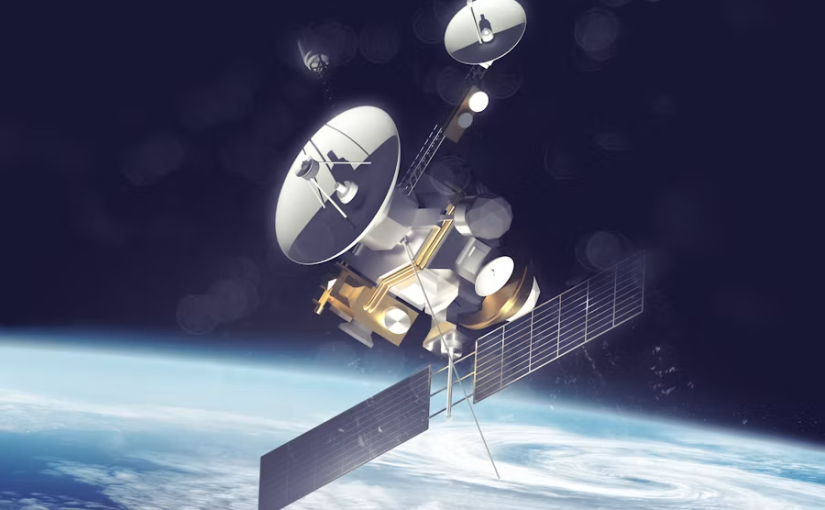
Instead of depending entirely on a nearby mobile tower, newer satellite technologies can connect compatible devices with satellites orbiting hundreds of kilometres above Earth. For New Zealanders who spend time hiking, fishing, farming, travelling or working in remote areas, that could make connectivity far less dependent on geography.

The technology is no longer simply something associated with science-fiction films. It is increasingly becoming part of everyday communications.

From Emergency Backup to Everyday Connectivity

For years, satellite communication was mainly associated with specialist equipment.

People heading deep into the New Zealand backcountry might carry satellite messengers, personal locator beacons or satellite phones. These devices could provide valuable communication when conventional mobile networks were unavailable, but they were additional pieces of equipment that had to be purchased, charged and carried.

The newer generation of satellite-to-mobile services is changing that model.

One NZ has expanded its satellite service beyond basic texting, allowing eligible customers with compatible phones and plans to access selected applications and WhatsApp functions when outside traditional mobile coverage. The service relies on a clear view of the sky and compatible hardware, but the basic concept is remarkably simple: the phone itself can communicate with a satellite network when a conventional mobile tower is out of reach.

That creates an important shift.

Instead of asking consumers to carry a completely separate satellite communication device for every trip, the industry is exploring how existing smartphones can become part of the satellite network.

For everyday users, convenience could be just as important as technical capability.

Why Rural New Zealand Could Benefit

Satellite connectivity is particularly relevant to New Zealand because of the country’s geography.

A farmer working several kilometres from the nearest town may move between areas with strong and weak coverage. A family travelling through a remote region may discover that their phones suddenly have no terrestrial signal. A tramper can leave a populated area and enter a valley where conventional mobile coverage disappears.

These situations are not necessarily unusual.

For businesses, the implications can be even greater. Agriculture, forestry, tourism, transport, construction and outdoor services can all involve workers operating away from dense urban networks.

A connected device can provide access to weather information, maps, messages and other important information without requiring a conventional cell tower nearby.

A modern GPS battery can therefore become part of a much larger conversation about outdoor technology. A GPS device may help users understand their location, record a route or support navigation, while satellite connectivity can potentially help transmit information beyond the reach of terrestrial networks.

The two technologies serve different purposes, but together they illustrate how location technology and communications technology are increasingly becoming interconnected.

Smartphones Are Becoming More Important

One of the most interesting aspects of satellite-to-mobile technology is that consumers may not need to completely change their habits.

The smartphone has already become the central device for navigation, communication, photography, payments and entertainment. Adding satellite connectivity gives it another potential role.

Recent One NZ information shows support for a growing range of iPhone and Android devices, although compatibility depends on the specific model, software and mobile plan. The company also states that users need a clear line of sight to the sky when connecting through its satellite network.

That last point is important.

Satellite connectivity does not mean that a phone suddenly works exactly like it does in the middle of Auckland. Trees, buildings, terrain and other obstructions can affect the connection. Satellite services can also have limitations on applications, capacity and data use.

Nevertheless, the ability to use a familiar smartphone outside conventional coverage represents a significant change in consumer technology.

For many people, the biggest innovation may not be the satellite itself. It may be the fact that the satellite is becoming almost invisible to the user.

Outdoor Recreation Could Be a Major Use Case

New Zealand’s outdoor culture makes satellite connectivity particularly interesting.

From hiking in national parks to boating around the coastline, New Zealanders regularly participate in activities where conventional mobile coverage can become unreliable or disappear completely.

For a tramper following a route, access to digital maps can provide useful situational information. For someone travelling through remote terrain, being able to send a message can provide reassurance. For outdoor businesses, connectivity can potentially make it easier to communicate with staff operating away from cities.

However, technology should not create a false sense of security.

Satellite smartphone connectivity is not a replacement for dedicated emergency equipment in every situation. One NZ itself states that its satellite service is not a replacement for a personal locator beacon or emergency beacon for people travelling in remote areas.

That distinction matters.

A smartphone is a multifunctional consumer device. A dedicated emergency device can be designed specifically for situations where communication and rescue are the priority.

The smartest approach is therefore likely to be layered rather than dependent on a single technology.

Battery Life Becomes More Important Off the Grid

There is another issue that becomes more important as connectivity moves beyond traditional networks: battery life.

In an urban environment, a smartphone can usually be recharged at home, in a car, at work or in a café. Someone spending several days in a remote part of New Zealand may not have that luxury.

Using navigation, GPS, cameras, mobile connectivity and satellite communications can all contribute to battery consumption.

This makes power management a critical part of outdoor technology.

A GPS tracker with a reliable GPS battery can be useful for maintaining location functionality during longer journeys, while a smartphone user may need to carry a power bank or another charging solution.

For hikers, hunters, anglers, farmers and outdoor workers, the question is no longer simply whether a device has the right features. The practical question is how long those features remain available when there is no convenient power outlet nearby.

That is an important consideration as connected devices become increasingly sophisticated.

Satellite Broadband Is Also Transforming Rural Internet

Satellite connectivity is not limited to smartphones.

Low Earth orbit satellite broadband has also become increasingly significant for rural households and businesses. Unlike traditional satellite systems that can rely on higher orbits, LEO networks use large constellations of satellites closer to Earth, helping deliver lower-latency internet services.

The New Zealand Commerce Commission has described LEO satellite services as a major change for rural connectivity. Its 2026 analysis reported that Starlink had grown to account for 27% of rural broadband connections, making it the largest rural broadband provider at that point.

This illustrates the scale of the transformation.

Satellite internet is no longer simply a niche option for people who live exceptionally far from infrastructure. It is becoming part of the broader competition over how rural New Zealand gets online.

For some households, satellite broadband can offer an alternative where fibre or terrestrial wireless infrastructure is difficult to deploy.

The Next Step: More Devices Beyond Phones

The future could involve much more than smartphones.

Satellite connectivity could eventually become increasingly relevant to trackers, vehicles, agricultural equipment, environmental sensors, emergency systems and other connected devices.

Imagine a remote farm where sensors collect information about equipment, weather or livestock. Imagine a boat transmitting its location while travelling far offshore. Imagine a hiking device updating a location record without relying on a conventional mobile tower.

These scenarios point toward a larger technological trend: connectivity is moving from specific places to individual devices.

This is particularly significant for New Zealand because remote areas have traditionally presented a difficult connectivity problem.

A small connected device may not need a massive communications infrastructure on the ground if it can communicate with a satellite overhead.

That could open opportunities for businesses developing products specifically for agriculture, tourism, conservation and emergency response.

New Emergency Communication Technologies Are Emerging Too

Satellite connectivity is also part of a wider effort to improve communications resilience.

In August 2026, New Zealand’s SafetyNet, Hourua and New Zealand Police tested a compact deployable cellular network in the Akatarawa Ranges, an area known for mobile coverage challenges. The system is designed to establish cellular connectivity where normal infrastructure is unavailable or disrupted, with wider testing planned before a proposed nationwide rollout for emergency services.

This development highlights an important point: the future of connectivity is unlikely to depend on one technology.

Satellite networks, mobile towers, fibre, portable networks and dedicated emergency communication devices can complement one another.

For a country exposed to earthquakes, storms, floods and difficult terrain, redundancy can be particularly valuable.

What This Means for Kiwi Consumers

For ordinary consumers, the arrival of satellite-enabled smartphones does not mean everyone needs to immediately change their devices.

Instead, it introduces another factor to consider when choosing technology.

Someone living in central Auckland may rarely need satellite connectivity. A farmer in a rural region, an outdoor enthusiast, a traveller or someone who frequently works away from towns may see much greater practical value.

Consumers should also pay attention to compatibility.

Not every phone supports every satellite service, and functionality can depend on the carrier, plan, operating system and location. One NZ’s current service information, for example, lists specific supported devices and notes that satellite features can vary between models.

Battery capacity, GPS functionality and charging options also remain important.

A device that offers impressive connectivity but runs out of power halfway through a remote trip is not particularly useful.

A More Connected New Zealand, Even Beyond the Towers

Satellite connectivity is changing the definition of what it means to be connected in New Zealand.

For decades, mobile connectivity was fundamentally linked to infrastructure on the ground. If there was no tower nearby, there was a good chance there was no mobile service.

That assumption is beginning to change.

LEO satellite networks, satellite-to-mobile technology and increasingly capable smartphones are creating another layer of connectivity above the landscape. For rural communities, outdoor users and remote businesses, that could make communication more accessible in places where traditional infrastructure has practical limits.

At the same time, consumers will need to understand what satellite services can and cannot do. Coverage does not automatically mean unlimited data, uninterrupted connections or guaranteed emergency communications.

The technology is still evolving.

But the direction is clear: New Zealand is becoming an important real-world testing ground for a future in which smartphones, GPS devices, vehicles and other electronics can remain connected far beyond the reach of conventional networks.

For anyone heading into the mountains, travelling across rural roads, working on a remote farm or exploring New Zealand’s coastline, that future could make the distance between connected and disconnected feel much smaller.

And as satellite connectivity becomes more common, even seemingly simple components such as a reliable GPS battery may become increasingly important to the wider ecosystem of devices helping New Zealanders navigate and communicate beyond traditional network coverage.

The next generation of connectivity may not be about building a tower everywhere.

It may be about making sure the sky can become part of the network.